Here’s a good breakdown of what’s approaching Thailand right now; a ‘super typhoon’ is based on wind speed in terms of classification, typically — over 120 mph would be ‘super.’ It’s likely going to hit an area recently affected by a terrible earthquake, but ideally it will hit at 125 mph (still insane by human comprehension) as opposed to its current 230 mph (which is around the EF-5 scale). There is a possibility that winds could be equivalent, at least initially, to Super Typhoon Tip, which is one of the most powerful storms ever recorded.
Take a look at the relative size of Super Typhoon Tip on its Wiki; ostensibly, it would extend from Seattle to Denver and down to Tucson if it was covering the U.S. It’s amazing that the death toll was only around 86; the 2011 tsunami killed almost 16,000. One idea of the strength of Yolanda involves the uprooting of coconut trees. Here’s one way to track the storm. Here’s an insane visual. It also appears the storm could impact metro Manila. Other good tracking options include this Weather Channel site and, of course, Twitter.
Typhoon Yolanda is getting stronger and faster: http://t.co/qxc3Fp9yf8 pic.twitter.com/9GiHnZH7nW
— Rappler (@rapplerdotcom) November 7, 2013
This Reddit thread is a good way for people to (a) stay abreast of information and (b) keep each other connected. There are 32 planes and helicopters involved in this process, along with three C-130 planes. It’s already essentially the most powerful storm of 2013, and ‘widespread destruction seems inevitable.’ The storm surge potential is an additional concern:
JMA surge model shows immense water inundation in Philippines as #YolandaPH/#Haiyan moves through. pic.twitter.com/4dwI4L2v3C
— Anthony Sagliani (@anthonywx) November 7, 2013
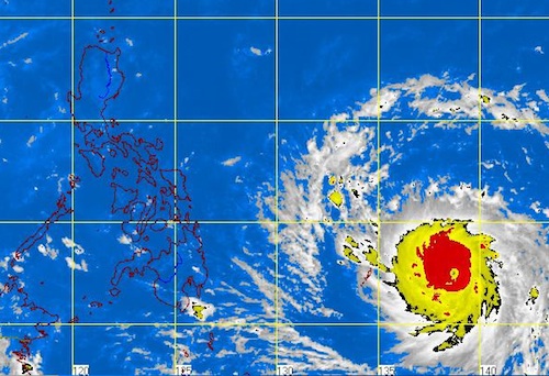
This is where it appears to be touching/passing over now-ish. There is an evacuation in progress, including some residents by force. At this point, we can all just pray for the Philippines (provided prayer is your thing) and hope for the best for its residents: